Altitude: 1188m to 1495m. Gain: 895m. Loss: 709m . Gradient: 12 deg (Moderate-hard)
Skills: Alpine weather (2/7)
Note: Described in the reverse direction to your journey
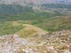
From the DOC sign at the end of the Ngapuketurua Track, follow the main ridge past Ngapuketurua's main peak then from the middle peak on the ridge, drop onto the broad spur heading south-east to the shallow saddle that marks the head of the Rangitikei River. Once across the marshy ground on the saddle, head into the beech forest - mostly open but with sections of tighter-packed pole beech - that covers pt 1257 then curl around the head of the Kakapo Stream to gain open ground as the ridge climbs up again. Terrain on the ridge is mostly easy, although herbfield and low scrub vegetation can make the footing a bit treacherous. The saddle between pts 1429 and 1345 gives fairly quick access to running water and enough flat terrain to pitch a fly.