Altitude: 825m to 1878m. Gain: 1069m. Loss: 203m . Gradient: 17 deg (Steep)
Skills: Prolonged scrambles (4/7) - Streams (2/6)
Note: Described in the reverse direction to your journey
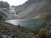
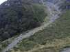
I passed Sleepy Hollow on the eastern side - good going on stable rock-scree. The pass from Sleepy Hollow to the Gorge is clearly visible at the head of the lake: it is the 'bite' shaped gap in the cliffs at the top of the scree on the left-hand side, just to the east of pt1973 on the map (2138600,558540). When I walked this pass in mid-January, all but the last 15m to the pass were free of snow and the route could be classed as a 'medium to hard scramble'. In snowy / icy conditions, this section would require alpine skills, and at minimum an ice-axe. The pass provides amazing views of Mt Bonpland, Glenorchy at the head of Lake Wakatipu, Mt Earnslaw and the Dart and Rees valleys. The descent to the plateau at the head of Gorge Creek receives more sunshine, and is be ice free for longer. The scree is fine and loose, and it is an easy scramble 100m down to the rocky plateau From the plateau below the Gorge / Sleepy Hollow pass, head north, keeping to the plateau and roughly the same altitude. A short scramble is necessary across the head of the Woodbine Station creek, but it is a relatively easy route to the cliffs above Glacier Burn, 1.5km from the pass. About 200m before the plateau ends in sheer cliffs, a ridge drops east to a col between the main range and pt1731. From this col (2139000,5587000), the gully shown on the map descends due north to the floor of Glacier Burn, losing 700m in about 1km. The going is steep, but reasonably stable. Glacier burn in very small in normal conditions, but could conceivably flood.
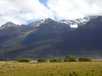
Following the Glacier Burn down, the track can be picked up after about 1km, entering the bush on the true left of the creek where it enters the beech forest.