
Distance: 2.7 km
(2.0 DOC hours)
- Unmarked route, clear
- Easy-moderate terrain

Altitude: 979m to 1544m. Gain: 244m. Loss: 726m . Gradient: 21 deg (Moderate-hard)
Skills: Prolonged scrambles (4/7)

Altitude: 979m to 1544m. Gain: 244m. Loss: 726m . Gradient: 21 deg (Moderate-hard)
Skills: Prolonged scrambles (4/7)
GPX info source: Uploaded from GPS
Note: Described in the reverse direction to your journey
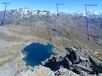
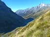
Initially in a small gut, the climb to Fohn Pass is fairly simple - go up. As altitude is gained, the pass comes into view - just head for it. From the pass, climb to the right. Follow a square gut down until the lake come into view then traverse, losing altitude, to the lake. Distributed camping in sheltered tussock is readily available.
Created by: Bernieq on 2015-06-22. Experienced: 2013-02-25
Route segments connecting with this one:
Places you can go from here:
(former) Lake Howden Hut (Hut)
(85 routes
Double Barrel Creek flats (Locality)
(21 routes
Emily Basin (Locality)
(92 routes
Harris Saddle Shelter (Locality)
(49 routes
Hidden Falls campspot (Campspot)
(6 routes
Kay Creek Hut (Hut)
(115 routes
Lake Mackenzie Hut (Hut)
(60 routes
Lake Nerine Camp Spot (Campspot)
(28 routes
Lake Sylvan carpark (Roadend)
(10 routes
Lake Unknown Bivy Rock (Rock Biv)
(16 routes
Lake Wilson Campsite (Campspot)
(37 routes
McKellar Hut (Hut)
(88 routes
McKellar Saddle (Locality)
(115 routes
Nereus Peak Ridge (Summit)
(19 routes
Rock Burn Rock Bivvy (Rock Biv)
(21 routes
Rockburn hut ruin (Campspot)
(10 routes
Routeburn Falls Hut (Hut)
(42 routes
Routeburn Flats Hut (Hut)
(20 routes
Routeburn Shelter (Roadend)
(16 routes
Scott Creek Car park (Other)
(29 routes
Scott Creek bush edge (Campspot)
(8 routes
Small Upper Fraser flat (Campspot)
(107 routes
Split Rock Biv - Beansburn (Rock Biv)
(8 routes
Theater Flat Campspot (Campspot)
(10 routes
Upper Caples Hut (Hut)
(89 routes
Upper Caples camp site (Campspot)
(122 routes
Upper Fraser Creek camp spots (Campspot)
(41 routes
Trips passing through here:
Comments:
Add
You are not currently signed in. Please register to comment