
Distance: 6.5 km
(2.5 DOC hours)
- Tramping track
- Easy terrain

Altitude: 473m to 521m. Gain: 127m. Loss: 107m . Gradient: 2 deg (Flat)
Skills: - Prolonged rivers (4/6)

Altitude: 473m to 521m. Gain: 127m. Loss: 107m . Gradient: 2 deg (Flat)
Skills: - Prolonged rivers (4/6)
GPX info source: Drawn on map
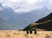
From the track to 25 Mile Hut (private and in poor repair), continue down the grassy flats of the Rees Valley, picking up poles to assist crossing the boggy Arthurs Creek.
Another 2km and the obvious track leaves the river and rises to cross Muddy Creek on a made road.
Last updated by: Bernieq at 2015-07-08 08:09:26. Experienced: 2009-04-12
Route segments connecting with this one:
Places you can go from here:
Centaur Peak (Summit)
(4 routes
Dans Paddock (Roadend)
(14 routes
Earnslaw Burn Rock Biv (Rock Biv)
(14 routes
Earnslaw Burn carpark (Roadend)
(14 routes
Earnslaw Hut (Hut)
/ Kea Basin rock biv (Rock Biv)
(24 routes
Esquilant Bivvy Hut (Hut)
(12 routes
Kea Basin rock biv (Rock Biv)
/ Earnslaw Hut (Hut)
(24 routes
Lochnagar Hut (Hut)
(6 routes
River Jordan (Roadend)
(14 routes
Shelter Rock Hut (Hut)
(4 routes
Trips passing through here:
Comments:
Add
You are not currently signed in. Please register to comment