


Altitude: 213m to 1243m. Gain: 443m. Loss: 1030m . Gradient: 11 deg (Moderate-hard)
Skills: Prolonged scrambles (4/7) - Occasional rivers (3/6)
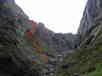
Follow the gently sloping rocky river bed SW from the Hut Creek forks towards Glade Pass. The valley turns a corner giving a full view of the steep slip-slopes rising to the pass. Look out for the last vegetated slope climbing from the valley floor up the true right valleyside. This slope has a rocky gully on its downstream side and continuous scree and bluffs upstream of it. Climb the vegetated gully towards a small dry waterfall which appears impassable. Observe a large rocky outcrop just to the left of the waterfall (looking up). Climb to the base of this rocky outcrop, where you will find a deer trail cutting across the rocky face and round into the gully above the falls. It is a brief scramble exposed to falls of a few meters.
Once above the waterfall, follow the gully up, climbing steeply on snow tussock and fern until you are on tussock faces above the heads of the bluffs/slips in the main valley (and just below bluffs leading to the peak above). Sidle these tussock faces onto the Glade Saddle.
From Glade saddle, brief good travel on rock and tussock leads down valley, before the valley becomes scrubby for 500m from the bushedge. Good deer trails on the TR lead through the scrub, but end at the bush. Follow the Glade Burn downstream, crossing as required. There are brief tough boulder / waterfall sections but good deer trails generally lead round each. If rivers are high, travel is possible for all but the last 500m on the true left, but it is necessary to cross to the true right for the last 500m above the Dore Pass track.
The Dore Track pass is well marked on both banks and can be followed 1km to Glade House.
Camp spots are very limited. The saddle has no water and is exposed but otherwise an option. There are dry but floodable spots on the terrace on the TR just inside the busedge. There are a few flat dry spots in the bush 500m up the Glade Burn, but all would flood in heavy rain. Potential dry safe campspots at the Dore Pass Track crossing are on the limit of the Milford Track camping exclusion zone, and also are right on the guided nature walk loop for guests at Glade House.
Forks to Glade House: 5-9hrs
For those headed in the reverse direction, occasional cairns mark this sidle and the upper section of the descent, but it would be very tricky to pick out the correct route to descend and as such the descent from Glade into Hut Creek is generally not recommended.
In late 2024, the success of pest control is obvious: there is no deer sign to see. Deer trails in Glade Burn are effectively NOT present so give no help and undergrowth browsing has stopped.
Travel is either in the steep stream bed or pushing through very thick undergrowth when stream travel not possible/safe. Going is slow and arduous. A lonely, wild, and scenic place.
Navigation crux of Glade Pass route is finding the rocky outcrop + waterfall to climb tò the pass from Hut Creek south branch. In late 2024, the "waterfall" is not present, would be dry is less than heavy rain. Red route on photo is good; get into the gut on the right (looking up) of the rocky outcrop (to the right of the rocky cascade prominent in the photo) then climb to the sky, to reach the tussock above the scrub line.
Climbing is steep-ish but safe if you stay in the gut. Always many small scrub handholds and rock footings.