Altitude: 174m to 1102m. Gain: 980m. Loss: 221m . Gradient: 10 deg (Moderate-hard)
Skills: Occasional scrambles (3/7) - Occasional rivers (3/6)
The falls at the base of Twin Falls Creek are ascended on the true left (west) side. Good deer trails climb steeply at times in bush on the spur just to the west of a small open stream-bed that descends 20m west of the main falls themselves. Once above the slipped-out section of the small creek, cut left (east) across its head and follow deer trails up the spur adjacent to the main river, leading to gentler faces sidling above the gorged section of valley above the falls. Remain sidling the face until the flat valley has opened up below you before cutting onto the valley floor and seeking out the river.
After a few hundred meters of following the deep / rocky river through boulder and windfall clogged bush flats, the riverbed becomes shallow, flat and gravelly with good beaches. From this point up the easiest route is to walk the beaches, wading the river from one to the next.
Excellent camp spots exist on open, dry, grassy clearings level with the base of the spur where the valley swings west - though these clearly flood in extreme weather conditions.
Above the small clearings, the valley starts to climb again and travel in the riverbed is no longer an option. There are intermittent deer trails on the true left (south) bank and progress from here seems easiest on this bank - though slow and often scrubby going.
For the lower of the two saddles (pt1099), pick up the spur climbing just upriver of the creek draining the pass, which can be hard to spot in thick bush with numerous small sidecreeks not shown on the map. If you come to a creek draining a large open slipped-out gully of rock and debris then you've just gone past it.
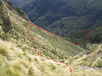
My route was to ascend the spur on the north side of the basin draining the pass. There are good deer trails up this from the point it starts to climb steeply, though locating its base can be tricky. You get frequent good glimpses to the 'lip' of the head basin as you climb. Drawing level with the lip of this basin (there is a small clear knob here if you are right on the spur) follow deer trails sidling level with/just below the basin lip into the head basin.
The head basin itself is choked with near-impenetrable scrub, but intermittent deer trails follow the bushedge across the lip, crossing creek which drains the basin and then climbing south, sometimes just inside bush, sometimes just in the scrub. Aim to climb to the last (most up-valley) beech tree on a small knob maybe 50m into the scrub on the southern valleside. From here an excellent deer trail cuts through very thick scrub climbing due south up the face until it exits scrub into tussock and low-scrub below the bluffs. Climb south to maybe 20m below the base of bluffs following the hard-to-spot trail through the tussock until you pick up a trail which makes a sidling climb to the pass at pt1099. The last section to the pass is moderately steep up a choice of rock-scree or snowgrass.
A gentle tussock valley drains the SE side of the pass to Lake Wapiti, with a good deer trail running down it. The trail drops a spur on the true right of the creek to the basin below, where the easiest travel seems to be on the dry, stable, scrub-free banks of the creek.
A few small camp spots exist on shoulders where the creek makes its final descent 40m into the lake. Alternatively tarns exist on the terrace 20m up the southern valleyside promising large dry campspots.
Base of twin falls - Lake Wapiti - 6-10 hrs