
Distance: 11.6 km
(8.0 DOC hours)
- Benched track
- Easy-moderate terrain

Altitude: 115m to 1604m. Gain: 2240m. Loss: 1087m . Gradient: 17 deg (Moderate-hard)
Skills: Occasional scrambles (3/7)

Altitude: 115m to 1604m. Gain: 2240m. Loss: 1087m . Gradient: 17 deg (Moderate-hard)
Skills: Occasional scrambles (3/7)
GPX info source: Uploaded from GPS
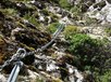
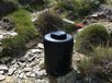
A well-marked and sustained climb from the valley floor up to pt 900 through significantly wasp-infested beech forest. The chain ladder sections leading to pt 1496 provide reassurance on straightforward but relatively exposed sections. Chains and bolts were in good condition and looked to have been quite recently replaced, in 2018. Just below the peak of pt 1496, a rain-filling water barrel with a spigot has been thoughtfully left: the 1300 m climb out of the Pelorus will very likely have drained your supplies. The ridge walk south over Mt Fell has great views through to Mt Richmond. Note that Mt Fell Hut has been moved a couple of hundred metres south from the location still shown on topo maps.
Created by: Bretts on 2021-01-31. Experienced: 2018-02-23
Route segments connecting with this one:
Places you can go from here:
Rocks Hut (Hut)
(3 routes
Roebuck Hut (Hut)
(3 routes
Fishtail Hut (Hut)
(3 routes
Richmond Saddle Hut (Hut)
(3 routes
Trips passing through here:
Comments:
Add
You are not currently signed in. Please register to comment