Warning: this route segment has been merged into Davids/Matakitaki forks to East Matakitaki Hut via Matakitaki River (Unmarked route, clear).
You are viewing a historic version of this route.


Altitude: 880m to 1840m. Gain: 2063m. Loss: 1263m . Gradient: 12 deg (Steep)
Skills: - Prolonged rivers (4/6)
(1) East Matakitaki Hut to the valley head
This was the most uncertain part of the trip. Hence I have included a lot of detail for those considering it. The head of the East Matakitaki is a beautiful valley, and would make a lovely place to camp.
No track is marked on the 1:50,000 topo map upstream from the East Matakitaki Hut. However, travel for approximately 1km upstream from the hut is easy going on the true left on river flats, with two river crossings deemed preferable to avoid a steep bush clad bank on the true left. At the river flow, with no significant rain for some days, these were thigh deep in places but easily manageable.
At the end of the river flats the slopes either side of the river become steep, with what appeared to be a gorge-like section. From here, at 930 m, a track has been made through the forest on the true left for about 1km, despite the map showing none. It begins roughly 70 m away from the river on the true left, at the bush edge. It is worth finding this, as the travel is reasonably easy going on this marked track, with markers reasonably frequent.
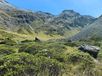
Beyond the end of this track there are sections of boulders, re-entering the bush, and unmarked track. From the clearing at 990 m travel is possible on the river flats on the true left. After this clearing the track re-enters bush on the true left, where it is rough and very overgrown, but avoids travelling in the riverbed / river crossings. The track then emerges to another clearing, crossing a side-stream from the true left at about 1035 m. From here the river steepens on occasion, requiring some travel over boulders. Travel is in and out of bush, crossing the river often to find the easiest travel and occasional clearings is possible, with some pushing through bush and scrambling up banks and steep grass slopes. Travel from 1,140 m is easier, with the bush starting to recede and the river not too steep. At 1,170m the river opens to wider river flats and by 1,200m the forest recedes completely, and the valley widens to boulder fields and beautiful grassy slopes meeting the stream (Figure 9a). From here the route to David Saddle is clearly visible, as is the bend in the valley where it turns east. Travel is easiest from here on the true left, requiring picking a route over tussock and between boulders and hebes. Just prior to turning east the route crosses a large slip and boulder field (Figure 9b). Travel is over stones and boulders on the true left, crossing to the true right at about 1,260m. The valley steepens significantly from here, with the river disappearing under boulders at one stage, and the route requiring hopping over large boulders. The route climbs steeply from here on the true right, over large boulders from a rockfall (Figure 10), with the stream eventually reappearing near the turnoff to D’Urville Pass, but some distance away, having headed towards the D’Urville Pass route. After the valley turns east the route up to D’Urville Pass is visible and becomes clearer. The very steep bluffs on its east side, and its narrow route, make it look almost impossible. However, on reaching the turn-off from the main East Matakitaki river a path up between the bluffs was clearly visible (Figure 11).
(2) Head of the East Matakitaki to D’Urville Pass
Reaching D’Urville Pass from the East Matakitaki turnoff is in two parts, separated by a rocky basin with a small tarn. The first part (Figure 11) involves a scramble up a chute between bluffs over boulders, stones, then scree on an increasingly steep slope. start on the left of the chute, but as it becomes steeper travel amongst larger rocky outcrops on the right is easier (Figure 11b). At the top of this chute is a large basin surrounded by bluffs, scree and full of enormous rocks (Figure 12a). However, travel is reasonably easy to the true left (south-east) of this, with D’Urville Pass clearly visible. The scree to D’Urville Pass steepens as the pass is reached requiring careful footing to avoid slipping back. Walking up to D'Urville Pass in the midday sun makes it a particularly tiring, with the rocks radiating heat. At this time and in this heat the scree and rocks seemed almost covered in grasshoppers with many alpine butterflies flying around the scree, and I believe I even spotted some alpine gecko.
The view from the pass looking back down the East Matakitaki (Figure 12b) shows the small tarn in the basin, which is obscured from view most of the way by the huge boulders in the basin. This would be a most unsuitable place to camp, with no grassy areas, just rocks and boulders.
(3) D’Urville Pass to Thompson Pass and Lake Thompson
From D’Urville Pass begins the long sidle around the head of the D’Urville valley to Thompson Pass. This sidle is best done at 1,700m elevation for most of it. However, careful route choice is required near Thompson Pass, as it is simply not possible to reach the scree/chute leading to Thompson Pass at this elevation, due to a long and wide crevice in the rock from about 1,800m elevation to 1,600m elevation, and possibly even further down to the valley – this is not shown on the 1:50,000 topo maps, nor are the large number of bluffs around here, nor the roughness of the ridge. It is particularly frustrating to encounter this crevice, as I did, as the scree/chute to Thompson Pass is tantalisingly close, at just over 100m away. This sub-section describes the descent from D’Urville Pass, the sidle at 1,700m, and my route to Thompson Pass.
The first part of the route is reasonably straight forward, descending scree to a fairly flat section with a small tarn. While it seems better to head south from D’Urville Pass, since that went toward the destination, this should be avoided, as it leads above bluffs. Instead stay north on the scree and continue to descend the scree, to the left of the rocks and bluffs as you descend. This is straight forward, with some careful clambering over a section of small vertical bluffs when almost at 1,700m elevation.
Most of the sidle is best done at 1,700m elevation, as described in other trip reports. Once on the flat section, at 1,700m, travel is straightforward, although over boulders at times. It then reaches steep boulder and scree slopes, which required careful footing and slow travel. Other trip reports describe beginning an ascent from about NNW of peak 1,964 to 1,770m. I continued further at 1,700m, then began an ascent to 1,800m – the sidle across the scree and boulders from higher looked more difficult, and the ascent to 1,800m after this was straightforward. I found a ledge, at this point, and began travelling towards Thompson Pass. However, I then encountered a very steep and rocky section, which I was not prepared to attempt to climb. Moreover, the ridge was significantly rougher than indicated by other trip reports and by the topo map, and while they talked about heading for the ridge, this did not seem wise. Therefore, I descended again to nearly 1,700m elevation where I found a grassy ledge that was an easy walk towards Thompson Pass. There were some small trickles of water in places, which could be useful near the end of the long traverse. In hindsight I wonder if it would have been better to only ascend to 1,740m and take what appears to be a ledge to these grassy ledges.
After walking along the grassy ledge I encountered the deep vertical crevice in rock, with Thompson Pass frustratingly close over the other side of it. Walking uphill beside this was reasonably easy on tussock, alpine plants and rocks. It eventually ended allowing travel northwest towards Thompson Pass. Soon after I encountered the bluff covered ridge line, and a narrow chute leading to the north-west side of the ridge above Thompson Pass. While the chute was narrow and steep, it was possible to scramble up it, including through a patch of snow, and no worse than some parts of the Waiau side of the Waiau Pass. After ascending this chute the ridge opens out to narrow grass ledges between steep rocky outcrops (Figure 16a). It was easy enough to pick a route between these, zigzagging down to Thompson Pass (Figure 17a).
As I stood on the pass, I saw to the north a group of five kea fly from the Waiau Valley side over the ridge and into the D’Urville Valley, calling out as they flew.
The walk to Lake Thompson down the Waiau side of Thompson Pass is a straightforward descent of 100m then contouring around a grassy rise from the ridgeline to the lake itself, taking just 20 minutes.