Altitude: 205m to 399m. Gain: 261m. Loss: 67m . Gradient: 4 deg (Moderate)
Skills: - Streams (2/6)
From the Ohutu bridge, head up the generally dry river bed - broad gravel. Occasional electric fences where the cocky has races across the river are the only hazard.
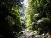
Nearing the park the riverbed narrows and becomes scrubby, and continues that way for 200-300m into the ranges. Travel is on slipper river rocks. Soon, however, a track appears on the northern bank, cutting between banks, and appearing / disappearing depending on the presence of flats. Travel is reasonable on track or riverbed to the first gorge, about 1.5km beyond the boundary.
The gorge is tight, sulphorous, red-stained, and definately a swim if you want to try it. A sidle track starts just downriver on the southern bank. marked by an old red national parks sign, and climbs some 60m above the valley before sidling upriver. The track rejoins the river half a km upstream.
After another 1km of riverbed travel a major forks is reached, with a stream joining from the north. A post, just below the confluence, with two triangles point vaguely NE, and indicated the start of the track to Duckville Hut. Confusingly the track starts at the forks on the upriver side of the forks, not at the post itself. On the opposite bank is a basic tarp camp.
All river travel is ankle-knee deep in normal flows. Like all rivers,, this could flood after rain.