
Distance: 1.6 km
(1.0 DOC hours)
- Unmarked route, clear
- Easy-moderate terrain

Altitude: 958m to 1195m. Gain: 237m. Loss: 0m . Gradient: 9 deg (Moderate)
Skills: Alpine weather (2/7)

Altitude: 958m to 1195m. Gain: 237m. Loss: 0m . Gradient: 9 deg (Moderate)
Skills: Alpine weather (2/7)
GPX info source: Drawn on map
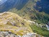
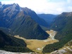
From Falls Hut head up the Routeburn to the first foot bridge you encounter. on the true right side of the foot bridge a stoney water coarse comes down the hill, parallel to the bluffs above. Leave the track and follow the water coarse to the south climbing up the hill past the bluffs. The ground trail swings northeastwards and goes past the big tarn on the map and over Point 1224. There are spectacular views here out over Routeburn Flats, much better then from the hut below.
Created by: Yarmoss on 2015-06-08. Experienced: 2008-04-01
Route segments connecting with this one:
Places you can go from here:
(former) Lake Howden Hut (Hut)
(92 routes
Double Barrel Creek flats (Locality)
(72 routes
Emily Basin (Locality)
(72 routes
Fohn Lakes (Campspot)
(42 routes
Glacier Burn roadend (Roadend)
(17 routes
Harris Saddle Shelter (Locality)
(32 routes
Hidden Falls campspot (Campspot)
(38 routes
Kay Creek Hut (Hut)
(113 routes
Lake Mackenzie Hut (Hut)
(56 routes
Lake Nerine Camp Spot (Campspot)
(61 routes
Lake Roberts (Waterbody)
(33 routes
Lake Sylvan carpark (Roadend)
(39 routes
Lake Unknown Bivy Rock (Rock Biv)
(48 routes
Lake Wilson Campsite (Campspot)
(40 routes
McKellar Hut (Hut)
(115 routes
McKellar Saddle (Locality)
(102 routes
Mid Caples Hut (Hut)
(102 routes
Nereus Peak Ridge (Summit)
(35 routes
Point 1197 (Summit)
(86 routes
Rock Burn Rock Bivvy (Rock Biv)
(67 routes
Rockburn hut ruin (Campspot)
(53 routes
Routeburn Flats Hut (Hut)
(52 routes
Routeburn Shelter (Roadend)
(77 routes
Routeburn Track (Locality)
(84 routes
Routeburn toilet (Locality)
(55 routes
Routeburn track 2 (Locality)
(55 routes
Scott Creek Car park (Other)
(76 routes
Scott Creek bush edge (Campspot)
(53 routes
Small Upper Fraser flat (Campspot)
(81 routes
Split Rock Biv - Beansburn (Rock Biv)
(39 routes
Steele Creek Hut (Hut)
(119 routes
Sunny Lake (Waterbody)
(21 routes
Theater Flat Campspot (Campspot)
(71 routes
Upper Caples Hut (Hut)
(124 routes
Upper Caples camp site (Campspot)
(92 routes
Upper Fraser Creek camp spots (Campspot)
(65 routes
Trips passing through here:
Comments:
Add
You are not currently signed in. Please register to comment