


Altitude: 1121m to 1953m. Gain: 1294m. Loss: 1637m . Gradient: 13 deg (Moderate-hard)
Skills: Prolonged scrambles (4/7) - Streams (2/6)
Note: The sidle from the large basin at the head of Pine Creek to the ridge line overlooking Lochnagar is extremely steep and exposed and almost entirely on snow grass. You have to go through two sets of bluffs. A slip would be serious. Only attempt this crossing in perfect conditions and carry an ice-axe or other means of arresting a fall.
From Rees Saddle climb to the southeast past a couple of small tarns (good camping) and make your way to where you can observe the stream shown on the map. Moirs talks about climbing up high, but the area above the stream is covered in fearsome looking bluffs. Instead, you can drop down to the northeast down a very steep snow grass bank between a smaller line of bluffs. The bank drops you down to Snowy Creek and in dry conditions is relatively straight forward. Follow the true left side of Snowy Creek up valley to the the base of the spur under the 570 grid line on the topomap.
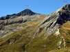
Climb the spur up moderate sloping snow grass almost to the top. The top of the spur bluffs out but simply sidle to the right beneath the bluffs until around them and then climb straight up on steep scree. The slope soon eases off and it's a further gentle climb on up the broad ridge around Point 1950. Peaks 2182 and 2223 both beckon as appealing side trips if you have time. Overlook the large rocky basin at the head of Pine Creek. By early February the snow shown on the map is almost all gone so it is an easy descent. Follow the infant Pine Creek around the basin and as it begins to exit the basin through a gorge leave the stream and climb gently to the southeast up the only easy slope north of Peak 2000. Take the flatish ground out of the basin and follow the terrain as it begins to drop down the hill. A small bluff to the south needs to be climbed through to reach the snow grass slopes of the sidle beyond, a narrow rocky ledge is the easiest route through.
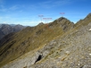
Sidle the very steep snow grass slopes around the top of Pine Cree, keeping high as you negotiate small gullies and the odd scree slope. Pay attention to the line of bluffs dropping down from Peak 1896, there is only 2 obvious breaks in the bluffs, themselves separated by a small bluff. Take the uphill one. It looks almost impossible until you are right upon it where a narrow snow grass ledge leads you into the bluff and straight through. The ledge leads to easier terrain on to the saddle between Peaks 1896 and 1865 where Lochnagar can be viewed.
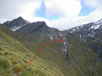
Descend snow grass towards Lochnagar. Scree slopes lead to a dry stream bed which provides good travel down for several hundred meters (the stream bed later becomes the stream shown on the map at CA11 525 536 which drops to the lake although in Feb 2016 it was dry the whole way down). Angle more and more leftwards (east) as you descend. The ridge line shown on the map dropping south from Peak 1865 is very rocky and bluffy higher up, keep to its edge on the grass. As you start to encounter the scrub band sidle southeastwards onto the ridge where a good animal track (Feb 2016) drops down it to the lake. Follow the animal track all the way down to the lake outlet. Cross on boulders here and then climb the slope to Lochnagar hut.
There is fantastic camping at small exposed beaches at the southern tip of the lake, 20 minutes from the hut, at about CA10 519 521. Cross rocky/scrubby/grassy terrain above the lake and drop down to the very small northern most beach. From here, simply rock hop around the corner on the lake shore to reach the 2nd beach or around a further corner to reach the 3rd. Both the 2nd and 3rd beaches have flat grassy areas to pitch tents on.
Route finding pretty straightforward as per instructions above. We took an ice axe & used micro spikes which made it feel better! Most committing part is climbing up the rocky ramp onto the start of the tussock sidle. The rest seemed ok if you take your time. Well worth it!
This route should not be taken lightly. All pretty straight forward until the Pine Creek sidle. This was beyond what our group felt comfortable with as the consequence for falling / slipping is extremely high. We ended up dropping down the SW side of the ridge between peaks 2000m and 2082m which resulted in us being bluffed out 200m from the lakes edge. 3 fit, capable and young trampers found themselves well out of there depths. In hind sight I believe the Pine Creek sidle is the only feasible route but its some proper scary shit. Those who have been before us were brave, those that go after us good luck . Note didn't see any cairns, plenty of water on the tops.