Altitude: 1536m to 1783m. Gain: 363m. Loss: 123m . Gradient: 10 deg (Moderate)
Skills: - Occasional rivers (3/6)
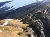
The poled route climbs a spur and passes through a saddle into an small flat valley. Rising a little then descending to Cascade Creek, there is a toilet and the only DoC sanctioned camping spot in the area. There is great camping over by some tarns between Heads Leap and Cascade Creek.
Cross the creek and climb 200m to where the pylon used toe be. As of Feb 2016 the pylon no longer exists but the area is heavily snow poled so follow them to where the decent into the Matukituki begins.
It is extremely hazardous to continue beyond this point - people have died. DoC recommends the Aspiring - Dart route for highly experienced trampers only - and only in the reverse direction. However, with the lower Dart track closed indefinitely the decent into the Matukituki is now regularly attempted by parties coming up from the Rees.