Altitude: 609m to 1579m. Gain: 1124m. Loss: 970m . Gradient: 9 deg (Moderate)
Skills: Occasional scrambles (3/7) - Streams (2/6)
Note: A crossing of Rabbit Pass involves 2 dangerous climbs, one on the infamous Wilkin waterfall face, the other on the East Matukituki cliff. This route should only be attempted in good conditions. While people do make the crossing south to north, this involves a down-climb of the waterfall face, in my opinion a more daunting prospect then going up it.
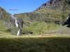
From Top Forks Hut markers lead into the bush where a decent track heads up Snow Bridge Gorge. Once out of the trees the track sidles through scrub up the gorge, which in 2010 was fairly overgrown in places. It takes about 3 hours to reach the snow grass flats which stretch from Waterfall Flat. As you make your way up the flats the impressive view of the valley head gets better and better. Theres a small rock biv under an obvious boulder near the head of the valley, a few hundred metres from the start of the Waterfall Route.
The route up the face starts well to the right (north) of the actual waterfall and initially climbs up a grass spur. It then sidles right (north) through bluffs, standing in boot holes kicked into the bank while hanging onto snow grass, before reaching a steep rocky section which you apparently go straight up on. In 2010 this was wet weepy rock following a couple of wet days. A grassy gut to the left (south) of the rock provides an alternative route up. At the top of the gut its a long climbing sidle to the left (south) which takes you to the top of the face, some 130m higher then the actual waterfall. This last sidle is extremely exposed and a slip would be fatal. Once at the top the views out over Waterfall Flat are fair reward.
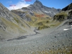
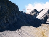
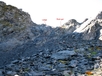
Drop down scree and rock to the infant Wilkin South branch and follow it southwards. Rock soon gives way to grass and alpine meadows. Pearson Saddle is an easy side trip from the valley floor and makes a great spot for a late lunch. Carrying on through Rabbit Pass the massive East Matukituki cliff drops away on your right as snow poles come into sight. Follow the poles eastwards along the top of the cliff as far as the 1600m contour where a final pole mounted in a cairn marks the start of the descent into the Matukituki. Descend down a steep zig zag though loose scree to reach the top of the cliff. In 2010 a marker lay about 30m below at the foot of a vertical gut. A narrow ledge, covered in loose, crumbly schist rock drops westwards down the bluff at a steep angle. Descend very carefully down the ledge, all the way to the bottom. Going is slow, and frequented with showers of loose rock down the ledge (and onto any party members below you). Like the Wilkin Waterfall face, I wouldn't even dream of attempting this in anything other then ideal conditions. Allow an hour to get down with a party of 2 people, much longer with larger parties simply due to falling rock hazard.
Once down the cliff head westwards down steep scree slopes following snow poles, and then southwards on snow grass until you eventually hit the stream coming down from Rabbit Pass. Best travel is in rock hopping in the stream to avoid scrub and flood damaged terrain. Flat terrain is finally reached down at about 800m. Follow the Matukituki down through grassy flats, crossing as required for the best travel. There's camping all down the length of the valley as far as Ruth Flat. To locate the upper rock biv leave the Matukituki when you reach the stream coming down from between Aspinall Peak and Peak 1828 and look for an overhanging cliff on the true right side of the stream a few dozen metres up from the Matukituki, well hidden by bushes. If you want to push on to Ruth Flat its further hour's easy walk.