From Dog Kennel Biv, head upstream on the northern bank. Cross to the south bank either at the forks or at good braids 200m downstream of the confluence. Head up the west bank of the southern branch across the flats to where a spur descends to the valley floor at the start of the gorge. The remains of an old stone hut mark the spot.
Climb the spur to terraces above and sidle south at about 1100m, keeping above lose, steep faces below. Once past the gorge, a good deer trail provides a route down to the creek just as it enters the first slot. It is advisable to cross here to the southern bank as the northern valleyside is scrubby.
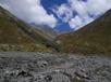
Reasonable travel follows up the southern valleyside, 10-40m above the creek in tall tussock until you reach easier travel on stable scree. The river disappears and soon after a small grassy medial moraine appears, dividing the gully climbing south to Brabazon Saddle from the main valley.
Note: Described in the reverse direction to your journey
From the base of the gully draining Brabazon Saddle, a good route heads downstream on first scree and tussock. The north face becomes scrubby but following the face of the scree to the south provides easy travel. As the valley swings NE tussock and scrub become a problem, and it is necessary to sidle the southern face 20m or so above the creek to stay out of scrub, The valley gorges out for the last 500m and both the south face and valley floor are impassable. A good deer trail just above the gorge gives access to terraces on the northern face. Once on them sidle at that altitude until you are above the main valley flats before dropping NE to the valley floor. Do not be tempted by earlier scree chutes - they all descend to bluffs below.
An old stone hut marks the point where the south branch hits the valley flats. Head downstream on good flats. Good crossings with braids are present some 200m below the forks - knee deep in normal flows. It the river is high is is best to cross here and follow the northern bank. Otherwise take the easiest route, crossing as necessary. Dog Kennel Biv is at the downstream end of a black of beech on the northern bank. A cut track leaves the northern riverbank 100m upstream and leads to the hut. From the southern bank the hut is just visible, but you could miss it.