Altitude: 1065m to 2145m. Gain: 731m. Loss: 1108m . Gradient: 11 deg (Moderate-hard)
Skills: Snow / ice (5/7) - Streams (2/6)
An alpine tramping route connecting Black Birch and the Macaulay via Tom Thumb Col. Snow / ice are likely to be present year round on the pass and ice-axe is required, crampons recommended.
Continue up the south branch of Black Birch Creek above the forks with the Brabazon Saddle gully. Climbing gently on good scree you soon reach a large flat basin with a huge boulder in the centre. A good sheltered rock-biv exists on the upstream side of this boulder - space for 2-3, but probably not tall enough to sit comfortably.
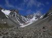
Access to Two Thumb Col is straight forward - continue up the main valley on loose rock / scree. Snow patches may provide better travel. Remain in the valley floor until directly below the saddle and then either climb to the saddle itself or up the vague spur 20m to its north. The last 1.5km to the col is continuously exposed to snow or rock fall from faces above - not a place to linger.
Once across Two Thumb Col, the descent south is simple. Snow was present down for the first 1km when I visited. Once out of the initial basin, the moraine ridge separating this fork from its northerly twin provides good travel all the way to the forks of the two major valleys (draining Tom Thumb and Electra).
Below the forks, valley floor travel is possible for about 2km though tussock & spaniard slow travel. Downriver of Captains Peak the valley gorges out and it is necessary to sidle the southern valleyside, remaining at the base of good stable scree (~1300m) on well used goat tracks until the gorge below is passed. Bluffs ahead block progress on the valleyside, but just before they are reached, a steep scree chute provides access to the valley basin below.
A small stream draining Captains Peak joins the main creek in this basin (shown on topomaps) 1.5km above the confluence of Tom Thumb Stream and North East Gorge. The spur downstream of this sidecreek provides good access to terraces leading down North East Gorge, the Macaulay and finally the Godley as far as Ray Simpson Hut.