Altitude: 856m to 1834m. Gain: 708m. Loss: 980m . Gradient: 15 deg (Moderate-hard)
Skills: Snow / ice (5/7) - Streams (2/6)
Note: Described in the reverse direction to your journey
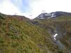
From Ballarat Hut a straight-forward, but prickly route leads up Ballarat Creek, hindered only by tall tussock and speargrass. Sidling the east face to the first forks may help. Follow Ballarat Creek to the 2nd major forks on the west side, a broad, grassy flat-bottomed creek draining the Ballarat-Auram saddle. You can follow this sidecreek upstream for a few hundred meters - the going is easy of short grass, but ultimately need to get on the spur to its south (leading to pt1872) before the face bluffs out too much. The spur has tall tussock and knee high scrub on it, and is slower going, but goat and deer trails provide some help. Things improve as you climb. Eventually you reach the grassy faces below pt1872, and can sidle north-west into the basin below the saddle - towards Mt Aurum. The saddle is simple - a walk on tussock and some rock. The southern side however, holds snow until well into summer, and is likely to be a descent on snow/ice. There was deep snow down to 1650m when I crossed in early December 2015. The main creek starts to gully out,m and it is necessary to sidle right onto the gentler sloped below Mt Aurum to avoid dangerous loose country in the gut itself. Follow the spur between the two creeks all the way to the valley floor - easy going with animal trails to help. A 2km walk down the flat valley floor follows - slowed by tall tussock. Aurum basin hut comes into view eventually on a low spur on the true right of the creek.