This is the 'middle' route sidling down the Tyndall at around 1200m. It is also possible to sidle out to the eastern valleyside at the height of the pass and follow that ridgeline to the confluence. That route passes through one band of bluffs and so some visibility would be useful.
Note that the attached gpx route drops too low in the middle section of the sidle and has to climb again - this can be avoided by not dropping whilst sidling.
Tyndall creek on the south side of the saddle descends to the valley floor via a waterfall, and so should not be followed . Instead follow the spur west of the creek down into the basin below, rejoining the creek at the first minor forks at around 1250m. Cross the creek to flats on the eastern side of the creek, cross the brief flats and from there sidle downriver keeping roughly the same altitude. At first there is a bit of low scrub, but soon you end up in good tussock, which slowly deteriorates back to knee high scrub as you head down valley. There are occasional steep sections and bluffs but they can easily be passed above or below as seems best. Do not be tempted by deer trails dropping into basins below - the scrub there is a nightmare. If in doubt - climb rather than descend.
Eventually the ridgeline to the east drops towards you. Sidle onto the ridge and follow it down towards where Tyndall Stream emerges onto Junction Flat. The eastern side of the ridgeline consists of sheer bluffs dropping all the way to the Tummel Burn below, but the western side is gentle tussock basins. At times Tummel Burn Hut can be seen - a very small dot almost vertically below on the flats. Occasional cairns will appear as you start to hit low scrub, followed by a single warratah with a white marker on top. It is important to locate this warratah, as continuing down the spur beyond it leads to impenetrable scrub and then bluffs.
At the warratah, sidle 50m right (i.e. back up the Tyndall Creek) through thick scrub, and drop into the basin of the side-creek to the NW of the spur we have been descending. The creek / gut is fairly open at first and can be descended with care down gravel chutes and short grass. In lower sections the route enters stunted bush on the TL of the gut for a while. The gut/creek drops into Tyndall Creek in a gorge 200m above Junction Flat. Moirs mentions a route sidling above the gorge, but it was not obvious to me.
The brief gorge can be descended with care on the TL with a bit of scrambling over boulders, crossing to the TR when the stream levels out as it approaches Junction Flat. Tummel Burn Hut is 50m from the start of the flats on the TL and is obvious.
Note: Described in the reverse direction to your journey
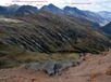
The "low" route to Shotover Saddle goes up Tyndall Creek. Records from the Tummel Burn Hut book dating back to the 70s don't recommend this route, neither does Moirs. The "high" route follows the spine of the ridge from Point 1550 over Peak 1781 and along the 1600m contour to Shotover Saddle. This would make a good route going from the saddle to Tummel Burn Hut. The "middle route" climbs to above the scrub line then sidles up the valley between the 1200 and 1300 meter contour before crossing Tyndall Burn at 1200m and climbing to the saddle on the true right of the main stream.
Note that the attached gpx route drops too low in the middle section of the sidle and has to climb again - this can be avoided by not dropping whilst sidling.
From Tummel Burn Hut look for a metal sign hanging from a bush on the true left of Tyndall Creek across from the hut. An ancient overgrown NZFS track sporadically marked with permalot makers pushes up the hill through bush through a fern chocked gully to the northwest from the river. Push through the ferns and light scrub in the bush, climbing until a dry creek bed is reached running northeast to southwest. There were 2 cairns here in Feb 2016.
Climb the creek bed sticking to it until dead trees from an old scrub fire are passed. Keep an eye out for a cairn which supposedly marks the turnoff to head due east from the creek bed. We missed it, but the creek bed terminates in a wall of scrub. A small, scrub filled off shoot from the main creek bed headed east from here. A short scrub bash eastwards out of the main creek bed and around the top of the off shoot bed through man eating scrub allowed us to reach a point where a metal warahtah stake with a permalot marker attached could be seen. The waratah marks the start point of a light trail which ran up the ridge line through thinning scrub and on to the open tussock slopes of the main ridge at about 1200 metres. If you are coming down then the waratah would be the point to head west to locate the dry creek bed.
From 1200m sidle tussock slopes through numerous gullies and interesting rock formations up valley until the big spur coming down from Peak 1781 is reached and the upper valley and creeks can be viewed. Descend to cross a gulch with the biggest tributary in it and make your way around to the main stream of Tyndall Creek, crossing it at about 1200m. Climb up tussock slopes on the true right of the stream to the small tarn shown on the map, there is good camping here or at the 2nd mapped tarn further to the east although that one is more exposed to wind coming over from the Matukituki. Its a short further climb up onto the saddle. On the north side of the saddle its a short steep descent down to the large tarn shown on the map which is sheltered from the south.
Red Rock makes for an interesting hour round side trip to a random patch of red ultramafic rock such as whats found in the Olivines to the west.