
Distance: 0.1 km
(3.0 DOC hours)
- Unmarked route, clear
- Easy-moderate terrain

Altitude: 776m to 1633m. Gain: 861m. Loss: 128m . Gradient: 39 deg (Moderate-hard)
Skills: Alpine weather (2/7) - Occasional rivers (3/6)

Altitude: 776m to 1633m. Gain: 861m. Loss: 128m . Gradient: 39 deg (Moderate-hard)
Skills: Alpine weather (2/7) - Occasional rivers (3/6)
GPX info source: Drawn on map
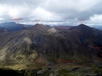
Cross to the true right of the Windon Burn and head up into the Spaniard infested valley southwest of Forks hut. You can follow the stream all the way to the valley head, or climb moderate slopesdirectly to the west from the 1200m contour to gain the lowest part of the ridge line between Pt1750 and 1659. The ridge line is broad with good scree almost as far as Pt 1588, which can be avoided on scree slopes beneath its eastern side. Traverse to the low point between Peak 1588 and Peak 1777.
Last updated by: Yarmoss at 2020-01-22 08:57:30. Experienced: 2019-12-16
Route segments connecting with this one:
Places you can go from here:
(former) Lake Howden Hut (Hut)
(22 routes
Acheron Lakes (Waterbody)
(5 routes
Army Hut (Hut)
(12 routes
Boyd Creek Carpark (Roadend)
(13 routes
Mararoa River Crossing (River Crossing)
(5 routes
McKellar Hut (Hut)
(14 routes
North Cascade Creek camp spot (Campspot)
(5 routes
Pt1543 (Summit)
(9 routes
The Divide (Other)
(16 routes
Upukerora Forest Flat Camp Spot (Campspot)
(17 routes
Upukerora River Upper Flats (Locality)
(15 routes
West Burn Hut (Hut)
(8 routes
Trips passing through here:
Comments:
Add
You are not currently signed in. Please register to comment