Make your way down the tussocky flats to the head of the gorge on the East Eglinton and cross the large side stream here. Climb steeply up to flat ground above the gorge side stream, then climb steadily to the southeast to reach the 1340m contour east of Point 1305, keeping west of the scrub on the climb up. Drop down into the large valley to the south and climb directly up to the top of the next ridge. Sidle southwestwards, past a small lake and across talus slopes to reach the main ridge line of the Livingstones between Peaks 1553 and 1508. From here you can drop straight down to the south to pick up the Winton Burn, or head over Pt 1508 to drop down past alpine bog lands and a large lake to reach the Windon Burn. Head down the Windon, crossing as required to avoid scrub and boulders, to eventually reach Forks hut.
Note: Described in the reverse direction to your journey
From Forks hut head westwards up the hill behind the huts and head up valley through tussock and occasional scrub. Under normal flows the Windon Burn can be crossed as required to avoid the worst of the terrain, but in general the open valley is pretty easy travel. After rain it not possible to cross the river until north of Pt 1397. A boulder field covered in scrub on the valley floor east of Pt 1557 can be avoided by crossing to the western side of the valley.
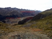
The Windon can be followed all the way to the head of the valley, climbing directly up to Pt1553 on decent scree, but a worthwhile route up to the ridge line involves going by the lake and swamp shown on the topomap. Cross a large side stream and climb the spur that comes off Peak 1711 at the 1060m contour and climb up to about 1300m before sidling northwards below the scree shown on the map. You'll soon reach a delightful area of alpine boglands and tarns with firm travel between the water features. Cross the outlet of the largest lake and climb directly northwards up onto the ridge line of the Livingstone Mountains at about Point 1508.
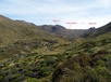
Follow the ridge line eastwards and either go up and over Point 1553, or do as I did and sidle under bluffs beneath it, at the head of the valley draining down into the East Eglinton. Sidle northeastwards across a mixture of scree, tussock and talus. Theres a lake at CC09 149 028 at the head of the northern branch of this first side stream which looked like it had good camp sites. Climb up to the ridge line between Point 1417 and Peak 1991 and then drop steeply down into a 2nd, larger valley containing a stream draining the northern slopes of Moffat Peak. Climb northwards out of the valley to the ridge line between Point 1305 and Peak 1731. From CC09 148 045 there is a steep but straight forward descent to the northwest all the way down to the floor of the East Eglinton, initially on rock/clay and then tussock and scrub. Skirt around bush and cross a large tussocky clearing to another steep descent down to a large side stream at the top of the East Eglinton gorge at 800m. Walk up the true left side of the East Eglinton, once clear of the gorge there are exposed camp sites by the river, or continue up the tussock flats for an hour to camp at the bush edge near where the eastern tributary drops into the flats.