Altitude: 593m to 1547m. Gain: 1504m. Loss: 1217m . Gradient: 11 deg (Moderate)
Skills: - Streams (2/6)
Note: Described in the reverse direction to your journey
Cross the lake outlet and circle the knoll to follow the outlet stream down a spur turning right with the stream and descend easily to the Olivine Ledge (1 hr).
Cross the TL arm of Fiery Ck and pick up the footpad that climbs to the Col. Descend into the bowl below the col and stay on the TL of the obvious gut. The route down is cairned and stays close to the gut edge. At the valley floor, cross a stream and stay close to the slope until through Cow Saddle (as the saddle is quite boggy). Once in Hidden Falls valley, travel is (mostly) fastest on the boulders/rocks in the dry river bed (the water is underground) until around the 780m contour. Pull out of the creek bed on the TR, to avoid forest on the TL, and descend to the treeline at 720m and cross to a track on the TL. Follow the well defined track through a clearing (good campsite) and continue on the TL until a major side stream is crossed. Now look for where the track turns away from Hidden Falls Creek and immediately begins the very steep climb to Park Pass.
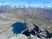
On the broad shelf, head towards the knoll at 1200m (with tarn - camp possible) taking great care as many deep channels and holes could easily break a leg of the unwary. From here the terrain becomes more rocky and Fiery Col comes into view.