Altitude: 1445m to 2001m. Gain: 594m. Loss: 592m . Gradient: 13 deg (Moderate)
Skills: Occasional scrambles (3/7)
Note: Described in the reverse direction to your journey
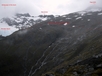
From the hut follow cairns up the hill to the east and follow them around the ridge line from Mt Armstrong. The route becomes convoluted with sporadic cairns but basically sidle around the head of a large gully roughly between 1600-1700m to reach the ridge line over looking the glacier. Drop down the ridge line to the west and then descend glacial polished rocks to the north to reach the floor of the valley carved by the glacier. Walk past the melt lakes and right up to the snout of the glacier. The stream shown on the map adjacent to the glacier is easily followed up the mountainside past the glacier and on up to the small lake below Point 1951. The Main Divide is easily walked along as far as Point 2023. The north face of Mt Armstrong does not look like a practical route to climb. Drop down long rocky slopes to the west to retrace your steps back to Brewster hut (or to climb Mt Armstrong). This circuit plus climbing Mt Armstrong takes about 7 hours.