Altitude: 981m to 1344m. Gain: 425m. Loss: 750m . Gradient: 16 deg (Moderate-hard)
Skills: Occasional scrambles (3/7) - Prolonged rivers (4/6)
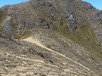
From the Mangamaire Valley, regain the tops to the west and continue south. The ground cover is herbfield and some low scrub, giving way to bare tops as you move south. After pt 1575, when you swing west towards Te Wetenga and Makorako, cairns start to appear. Makorako is a 40-60 minute return side trip from pt 1699 - in snow-free conditions. From pt 1699, it's a steepish drop down the spur to the north-west; the ground trail is fairly obvious and the cairns continue. A couple of little gendarmes need to be climbed or turned on the ridge to the east of pt 1466. Straightforward going along the ridge once you turn north towards Te More, but no more cairns. Around the low point on the ridge before Te More, heavy scrub and low beech have been able to grow right over the ridge, which makes getting through to Te More (and on to the spurs dropping west into the Rangitikei) a challenge. i chose to drop into the trib to the west, which was very hard going for the first couple of hundred vertical metres. Might be better to take a spur further south? Or persist with the scrub on the ridge to get to the spurs north-west of Te More? Once in the Rangitikei, easy (in summer flows) river bash northwards.