
Distance: 2.3 km
(2.0 DOC hours)
- Unmarked route, clear
- Easy-moderate terrain

Altitude: 1168m to 1933m. Gain: 14m. Loss: 771m . Gradient: 21 deg (Moderate)
Skills: Occasional scrambles (3/7)

Altitude: 1168m to 1933m. Gain: 14m. Loss: 771m . Gradient: 21 deg (Moderate)
Skills: Occasional scrambles (3/7)
GPX info source: Drawn on map
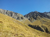
Sidling north from the Temple-Ahuriri pass, dropping slightly as you go leads across stable screen faces below pt 2058 to the ridge just east of V-Notch pass. Drop to the pass staying on scree south of the summit rocks - I crossed some 20m east of the V notch itself.
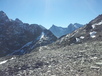
Drop into the head basin. The creek becomes impassable, so sidle west onto good open tussock spurs. The eastern valleyside is also passable but very scrubby lower down - I don't recommend the experience.
Created by: Madpom on 2014-11-19. Experienced: 2012-04-04
Route segments connecting with this one:
Places you can go from here:
Campspot (Campspot)
(4 routes
Forbes Hut (Hut)
(1 route
Grough Hut (Hut)
(10 routes
Huxley Lodge roadend (Roadend)
(4 routes
Monument Hut (Hut)
(10 routes
South Temple Hut (Hut)
(5 routes
Temple shelter and campground (Campsite)
(5 routes
Top Hut (Hut)
(6 routes
Trips passing through here:
Comments:
Add
You are not currently signed in. Please register to comment