Altitude: 536m to 2053m. Gain: 902m. Loss: 1518m . Gradient: 16 deg (Steep)
Skills: Prolonged scrambles (4/7) - Streams (2/6)
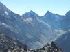
A steep and exposed pass connects the Sth Huxley and Hunter - the Huxley side being the tough one.
From the base of the creek draining V-notch pass, continue up the South Huxley. Two streams bracket a broad scree slope leading towards the pass south of College Peak. Head up this slope, aiming to hit the base of the spur on it's northern side where the scree give out to rock and tussock. Climb this spur until it starts to bluff out at around 1700m. From here a steep tussock face allows a sidling climb back towards the creek on the southern side, where the spur may be climbed in a zig-zag between two levels of bluffs. Once above the 2nd bluffs you find yourself on good open screen faces leading all the way to the pass - and easy climb after what went before. 2-4 hrs to pass.
The accompanying photo gives a clear indication of this route.
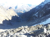
The western side of the pass is easier. Descend good scree into the head of the creek south of College Peak. Follow the creek downriver to where it starts to gorge out at the bushedge. Afdter brief scrub, I then sidled south through good beech onto the next spur south and followed that down to the Hunter Valley floor. 2-4 hrs from pass to valley floor.
Forbes hut is 600m upriver on the eastern bushedge.