Altitude: 810m to 1598m. Gain: 788m. Loss: 0m . Gradient: 32 deg (Moderate-hard)
Skills: Occasional scrambles (3/7) - Streams (2/6)
Note: an ice axe should be carried for the south side of Emily Pass which usually holds snow well into summer, and for the north side which consists of steep, slippery snow grass above bluffs..
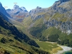
From the true right side of Emily Creek bridge push through ferns on the upstream side and follow the path of least resistance roughly parallel to the stream for about 20m until you get deposited on the edge of Emily Creek. Climb the creek bed, which is initially quite bouldery, all the way up to 1200m. The going gets better about 100m up from the bridge with travel in the main creek bed generally being best on the true left side.
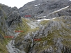
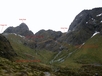
At about 1200m a slip enters the creek on the true right. Climb here up scree to reach the northwest corner of Emily basin at about CB09 205 352. The obvious low point on the ridge above is Fraser Col (marked as Point 1544 on the map), Emily Pass is out of sight to the right of Emily Peak from here. Sidle across the western side of the basin making for an obvious rocky gut with a stream exiting it. Go up the gut, cross the stream and go past a waterfall coming down the rocky side. At the head of the gut climb up a nearly vertical rock and grass face beside a 2nd smaller waterfall, then sidle to the right (north) to reach easier grass slopes. Climb these to the southwest to gain Emily Pass.