Altitude: 1253m to 1471m. Gain: 50m. Loss: 268m . Gradient: 12 deg (Moderate)
Skills: Occasional scrambles (3/7) - Occasional rivers (3/6)
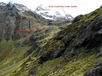
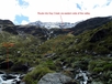
Note: This is not the usual way down the bluffs at the head of Kay Creek. You are supposed to go down on the true right of the waterfall at the valley head. I went this way, and found it to be a viable route, as I was initially heading to Sleepy Hollow and had to change plans due to weather. It works though.
From the Scott Creek/Kay Creek Saddle descend down into the basin above the Kay Creek waterfall and then head southeastwards along the valley flank to reach the stream dropping into Kay Creek from the east on the topo map. Steep, bluffy terrain looks initially impossible, but a series of ledges zigzag down through small bluffs down onto steep snow grass and are quite straight forward. From here drop down to Kay Creek to the confluence of the two branches.