
Distance: 2.5 km
(1.5 DOC hours)
- Unmarked route, clear
- Moderate-hard terrain

Altitude: 1405m to 1587m. Gain: 254m. Loss: 141m . Gradient: 9 deg (Moderate-hard)
Skills:

Altitude: 1405m to 1587m. Gain: 254m. Loss: 141m . Gradient: 9 deg (Moderate-hard)
Skills:
GPX info source: Drawn on map
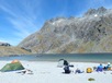
From the north shore of Lake Nerine, walk to the west side and climb to the low saddle. From here, there are two routes to North Col.
The low route descends to the 1440m ledge and contours around to the gully below North Col - then up. There are useful cairns along the route.
If visibility is questionable, use the low route. The high route takes slightly longer (and would be very challenging in poor weather).
Last updated by: Bernieq at 2015-06-25 10:13:40
Route segments connecting with this one:
Places you can go from here:
(former) Lake Howden Hut (Hut)
(129 routes
Double Barrel Creek flats (Locality)
(55 routes
Emily Basin (Locality)
(122 routes
Fohn Lakes (Campspot)
(28 routes
Harris Saddle Shelter (Locality)
(55 routes
Hidden Falls campspot (Campspot)
(28 routes
Kay Creek Hut (Hut)
(159 routes
Lake Mackenzie Hut (Hut)
(86 routes
Lake Sylvan carpark (Roadend)
(18 routes
Lake Unknown Bivy Rock (Rock Biv)
(25 routes
Lake Wilson Campsite (Campspot)
(44 routes
McKellar Hut (Hut)
(137 routes
McKellar Saddle (Locality)
(182 routes
Nereus Peak Ridge (Summit)
(12 routes
Rock Burn Rock Bivvy (Rock Biv)
(35 routes
Rockburn hut ruin (Campspot)
(18 routes
Routeburn Falls Hut (Hut)
(61 routes
Routeburn Flats Hut (Hut)
(26 routes
Routeburn Shelter (Roadend)
(28 routes
Scott Creek Car park (Other)
(105 routes
Scott Creek bush edge (Campspot)
(22 routes
Small Upper Fraser flat (Campspot)
(136 routes
Split Rock Biv - Beansburn (Rock Biv)
(24 routes
Theater Flat Campspot (Campspot)
(18 routes
Upper Caples Hut (Hut)
(173 routes
Upper Caples camp site (Campspot)
(170 routes
Upper Fraser Creek camp spots (Campspot)
(70 routes
Trips passing through here:
Comments:
Add
You are not currently signed in. Please register to comment