Altitude: 675m to 1851m. Gain: 2573m. Loss: 2217m . Gradient: 20 deg (Moderate)
Skills: Occasional scrambles (3/7) - Occasional rivers (3/6) Winter - Snow/ice underfoot, avalanche risk (3/7)
Note: Described in the reverse direction to your journey
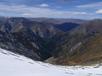
Moirs Guide recommends not using Monument saddle due to the eastern descent, but by following the route described here the bluffs on that side can be avoided. From Wallers Hut, sidle the face at the altitude of the hut until the next creek, where you can drop to the now-flat riverbed above the gorge. A riverbed / bank route follows travelling 3km up the northern fork of Wallers Creek. The creek climbs steeply for much of this time and travel is on steep tussock banks or short shingle faces just above the creek. Arriving in the head basin, the creek forks into 3 (the map shows only the southern 2 forks). Climb the spur between the southern 2 forks (shown on the map), heading due east to Monument Saddle. The climb is steep but good, with only a brief section of loose shingle scree 80m below the summit. The descent east from Monument is made tricky by several layers of bluffs - none of which are fully visible from the saddle itself. Head south to the southern end of the saddle, and descend the face below pt1987, crossing east over all the major streams you can see descending above the points where they start to gorge out. Once across, head directly downhill. All the small streams combine into two major flows lower down, with a narrow, tall spur between them. Aim for the top of that spur. Follow the centre spur down. The spur is interrupted by 3 bluffs, but all can be passed by sidling the past southern side of the bluff. avoid dropping into the southern fork too soon as it has impassable falls low down. Finally the spur becomes very narrow and reaches a small copse of beech. Here finally you can follow good goat trails dropping steeply south through the beech into the southern fork below the last waterfalls. From here it is a 'simple' case of following the creek downstream. You soon enter beech forest. The creek has various falls and pools and a few sort sidles (true left) are required early on. Later the riverbed becomes choked with windfall and progress is slow. The only impassable section was just above the major north and south forks of the Monument. A sidle on the true right was possible, but drop as soon as possible back to the river to avoid becoming bluffed higher up. The remaining section to the Stoney has good shingle but the southern bank is subject to frequent slips so conditions may change. Arriving at Stoney Creek, stick to the western bank and follow the Stoney 400m downriver to where Stoney Creek Hut sits in a flat clearing 20m from the river.