Altitude: 680m to 1663m. Gain: 1857m. Loss: 1621m . Gradient: 11 deg (Moderate-hard)
Skills: Prolonged scrambles (4/7) - Occasional rivers (3/6)
Two common routes exists from Stoney to Oxburn. Moirs recommends Stony Saddle, but the route described here is via Dismal Saddle. This route was snow-free in spring, whereas Stoney would still have required ice-axe and crampons.
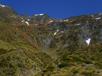
From Stoney Hut, follow the valley upriver. You can stay on the true-left for about 2km, sidling well-used goat trails past the first gorge. Once above the gorge frequent crossings are required to avoid bluffs and many pools and waterfalls are present. A few minor scrambles are required, but no large climbs. A lot of time is spent sidling low on shingle faces on the eastern valleyside - a pole / axe was handy. Tussock becomes low scrub higher up, but nothing too difficult.
At the last major forks the Stoney Pass route is visible climbing NE between the two creeks to pt1934/Stoney Saddle. For Dismal Saddle, however, follow the western fork through more tussock and gorges to the head basin.
The face below the saddle is steep and bluffed and not viable. To the left (south) two creeks are visible descending in waterfalls from pt1704. Take the spur south of these and climb until you pass all the bluffs, then sidle/climb north below the steep face of pt1704 towards the saddle. I would strongly recommend an ice-axe or good pole for this climb as you spend a lot of time on steep, exposed tussock faces and a slip could be fatal.,
Once on Dismal Saddle, head 100m south, peering into the Oxburn until you can see clear screen dropping the first 100m below you. The section directly west of the saddle has a line of bluffs, not visible but just below the saddle. Once onto the tussock any route works. Drop to the valley floor and follow good wide river flats downstream. After 2km the creek drops into a tussock V slot, but travel on the southern terrace is still good for another 800m until the whole valley gorges. Cross and sidle the gorge on the northern face, on steep scree and tussock faces. If the river is high, you probably want to cross to the northern bank much further up, as the crossing here could easily be impossible after rain.
The gorge ends just upstream of the major NNE / SE forks. These were swift and knee deep in normal spring (meltwater) flows. They could easily be impassable after rain. An easy kilometer remains on tussock flats to Cash's Flats Hut. The northern bank here, and the hut are private, and permission is required from Temple Peak Station.