
Distance: 5.3 km
(3.0 DOC hours)
- Unmarked route, clear
- Moderate-hard terrain

Altitude: 1418m to 1726m. Gain: 584m. Loss: 491m . Gradient: 12 deg (Moderate-hard)
Skills: Occasional scrambles (3/7) - Prolonged rivers (4/6)

Altitude: 1418m to 1726m. Gain: 584m. Loss: 491m . Gradient: 12 deg (Moderate-hard)
Skills: Occasional scrambles (3/7) - Prolonged rivers (4/6)
GPX info source: Uploaded from GPS
Note: Described in the reverse direction to your journey
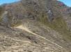
After pt 1575, when you swing west towards Te Wetenga and Makorako, cairns start to appear. Makorako is a 40-60 minute return side trip from pt 1699 - in snow-free conditions. From pt 1699, it's a steepish drop down the spur to the north-west; the ground trail is fairly obvious and the cairns continue. A couple of little gendarmes need to be climbed or turned on the ridge to the east of pt 1466.
Last updated by: Admin at 2022-05-31 06:38:07. Experienced: 2021-01-26
Route segments connecting with this one:
Places you can go from here:
Boyd Hut (Hut)
(20 routes
Cascade Hut (Hut)
(13 routes
Ecology Confluence (Campspot)
(4 routes
Kiko Rd (Roadend)
(6 routes
Makorako (Summit)
(4 routes
Mangamaire R headwaters (Locality)
(9 routes
Thunderbolt Range Access (Junction)
(4 routes
Thunderbolt camp (Campspot)
(4 routes
Waipakihi Hut (Hut)
(5 routes
Trips passing through here:
Comments:
Add
You are not currently signed in. Please register to comment