
Distance: 2.3 km
(1.0 DOC hours)
- Unmarked route, clear
- Moderate-hard terrain

Altitude: 1349m to 1499m. Gain: 187m. Loss: 328m . Gradient: 13 deg (Moderate-hard)
Skills: Occasional scrambles (3/7) - Prolonged rivers (4/6)

Altitude: 1349m to 1499m. Gain: 187m. Loss: 328m . Gradient: 13 deg (Moderate-hard)
Skills: Occasional scrambles (3/7) - Prolonged rivers (4/6)
GPX info source: Uploaded from GPS
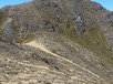
Straightforward going along the ridge once you turn north towards Te More, but no more cairns. Around the low point on the ridge before Te More, heavy scrub and low beech have been able to grow right over the ridge, which makes getting through to Te More (and on to the spurs dropping west into the Rangitikei) a challenge.
Last updated by: Admin at 2022-05-31 06:27:06. Experienced: 2021-01-26
Route segments connecting with this one:
Places you can go from here:
Boyd Hut (Hut)
(20 routes
Cascade Hut (Hut)
(13 routes
Ecology Confluence (Campspot)
(4 routes
Kiko Rd (Roadend)
(6 routes
Makorako (Summit)
(4 routes
Mangamaire R headwaters (Locality)
(9 routes
Thunderbolt Range Access (Junction)
(4 routes
Thunderbolt camp (Campspot)
(4 routes
Waipakihi Hut (Hut)
(5 routes
Trips passing through here:
Comments:
Add
You are not currently signed in. Please register to comment