
Distance: 1.0 km
(1.0 DOC hours)
- Unmarked route, clear
- Moderate terrain

Altitude: 1240m to 1544m. Gain: 4m. Loss: 304m . Gradient: 19 deg (Moderate-hard)
Skills: Occasional scrambles (3/7) - Streams (2/6)

Altitude: 1240m to 1544m. Gain: 4m. Loss: 304m . Gradient: 19 deg (Moderate-hard)
Skills: Occasional scrambles (3/7) - Streams (2/6)
GPX info source: Drawn on map
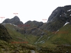
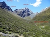
On the north side descend on rock then grass into Emily Basin and climb to the northwest to hit the extreme true left tributary of Emily Creek. Look for a scree slope which drops down into the creek from the northwest ridge of Emily Basin. Alternatively a cairn is at the lowest point of the ridge before the ground drops away to the north, and another cairn marks a light trail down through scrub into Emily Creek. If you are at the tree line in the basin then you are too far east, do not attempt to descend down through the trees from Emily Basin.
Last updated by: Madpom at 2018-02-04 07:53:05. Experienced: 2015-01-21
Route segments connecting with this one:
Places you can go from here:
(former) Lake Howden Hut (Hut)
(101 routes
Double Barrel Creek flats (Locality)
(44 routes
Fohn Lakes (Campspot)
(104 routes
Glacier Burn roadend (Roadend)
(23 routes
Hidden Falls campspot (Campspot)
(98 routes
Kay Creek Hut (Hut)
(105 routes
Lake Mackenzie Hut (Hut)
(71 routes
Lake Nerine Camp Spot (Campspot)
(125 routes
Lake Roberts (Waterbody)
(33 routes
Lake Sylvan carpark (Roadend)
(85 routes
Lake Unknown Bivy Rock (Rock Biv)
(95 routes
Lake Wilson Campsite (Campspot)
(88 routes
McKellar Hut (Hut)
(127 routes
McKellar Saddle (Locality)
(108 routes
Mid Caples Hut (Hut)
(120 routes
Nereus Peak Ridge (Summit)
(66 routes
Point 1197 (Summit)
(86 routes
Rock Burn Rock Bivvy (Rock Biv)
(135 routes
Rockburn hut ruin (Campspot)
(118 routes
Routeburn Falls Hut (Hut)
(82 routes
Routeburn Flats Hut (Hut)
(83 routes
Routeburn Shelter (Roadend)
(108 routes
Routeburn Track (Locality)
(84 routes
Routeburn toilet (Locality)
(55 routes
Routeburn track 2 (Locality)
(64 routes
Scott Creek Car park (Other)
(56 routes
Scott Creek bush edge (Campspot)
(35 routes
Small Upper Fraser flat (Campspot)
(89 routes
Split Rock Biv - Beansburn (Rock Biv)
(93 routes
Steele Creek Hut (Hut)
(125 routes
Sunny Lake (Waterbody)
(24 routes
Theater Flat Campspot (Campspot)
(115 routes
Upper Caples Hut (Hut)
(117 routes
Upper Caples camp site (Campspot)
(85 routes
Upper Fraser Creek camp spots (Campspot)
(52 routes
Emily Creek Bridge (Bridge)
(63 routes
Emily Pass (Pass)
(59 routes
Trips passing through here:
Comments:
Add
You are not currently signed in. Please register to comment