Altitude: 981m to 1544m. Gain: 563m. Loss: 0m . Gradient: 20 deg (Moderate-hard)
Skills: Occasional scrambles (3/7) - Streams (2/6)
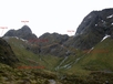
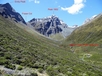
Note: The south side of Fraser Col usually holds snow well into summer and an ice axe might be required, although after a mild winter this is all gone by January.
From the small flats in the upper Fraser Valley you can continue to follow the creek up through the scrub to reach a vast tongue of scree and talus which descends right down from Fraser Col and go up from there, or you can do as I did which is head a short way up stream and then climb talus up the western side of the valley to eventually climb above the scrub belt, and then climb and sidle northwards up the valley, eventually hitting the rubble coming down from Fraser Col at about the 1300m mark. Climb from here straight up to the top of the col, 2.5 hours from the flats.