
Distance: 6.9 km
(3.0 DOC hours)
- Tramping track
- Easy-moderate terrain

Altitude: 305m to 1078m. Gain: 5m. Loss: 778m . Gradient: 7 deg (Moderate)
Skills: - Streams (2/6)

Altitude: 305m to 1078m. Gain: 5m. Loss: 778m . Gradient: 7 deg (Moderate)
Skills: - Streams (2/6)
GPX info source: Drawn on map
Note: Described in the reverse direction to your journey
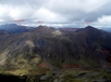
From the car park follow a 4WD track up the hill until a sign points the way to the "Boyd Creek Tops", a short distance before the Southland Boys Highschool owned Boyd Creek Lodge. A well marked backcountry track crosses scrubby terrain and then climbs up through bush all the way to bush line where one last marker stands on a free standing pole out in the tussock. There is a rock biv about 5 minutes from the bush line, under an overhanging bank. Large and seems dry, but very little flat ground. There is plenty of great camp sites at the bush line. Water can be found 100m south of the track end from tarns.
Last updated by: Yarmoss at 2023-01-08 20:15:55. Experienced: 2022-12-09
Route segments connecting with this one:
Places you can go from here:
Army Hut (Hut)
(6 routes
Forks Hut (Hut)
(13 routes
Upukerora River Upper Flats (Locality)
(4 routes
Trips passing through here:
Comments:
Add
You are not currently signed in. Please register to comment