
Distance: 7.2 km
(5.0 DOC hours)
- Unmarked route, clear
- Moderate terrain

Altitude: 878m to 1458m. Gain: 467m. Loss: 595m . Gradient: 9 deg (Moderate)
Skills: Alpine weather (2/7) - Streams (2/6)

Altitude: 878m to 1458m. Gain: 467m. Loss: 595m . Gradient: 9 deg (Moderate)
Skills: Alpine weather (2/7) - Streams (2/6)
GPX info source: Drawn on map
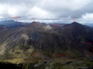
Cross open tussock tops, keeping high to avoid swampy terrain, to the southern branch of Walker Creek draining the Countess Range tops. Climb up tussock between sub-branches of Walker Creek to reach scree, and ascend to the obvious low point of the range between Winton Peak and Peak 1690. From the top, Peak 1690 can be easily climbed as a side trip by following the ridge south. Descend northeast from the ridge of the Countess Range into the stream valley draining southeastwards from Winton Peak. Follow the stream all the way down into the Upukerora Valley, negotiating scrub at the bottom. Descend the broad, tussock covered valley to find shelter in the tree line 1.5km away if required.
Last updated by: Yarmoss at 2023-01-08 20:18:21. Experienced: 2015-03-01
Route segments connecting with this one:
Places you can go from here:
Army Hut (Hut)
(6 routes
Boyd Creek Carpark (Roadend)
(5 routes
Forks Hut (Hut)
(13 routes
Upukerora River Upper Flats (Locality)
(4 routes
Acheron Lakes (Waterbody)
(4 routes
Trips passing through here:
Comments:
Add
You are not currently signed in. Please register to comment