Altitude: 478m to 980m. Gain: 556m. Loss: 57m . Gradient: 4 deg (Gentle)
Skills: - Prolonged rivers (4/6)
Note: The Upper Caples Hut was given/sold to the New Zealand Deerstalkers Association in mid 2014. It is now a private, locked hut. All track markers and signs between the Caples Track and the Caples swing bridge, which used to pass by the hut, have been removed. The track on the true right of the swing bridge now heads southeast straight up to the Caples track, several hundred meters west of the hut. As the Caples track actually passes to the west of the hut (this is shown incorrectly on the map) you wouldn't know it was there walking along the Caples track if you weren't looking at the now obsolete map.
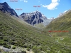
From the clearing on the true left of the Caples swing bridge follow the track into the trees to reach a T intersection of tracks. Take the left hand track leading to the Fraser valley. The track climbs up over the side of the valley, not following the river as the map shows, and eventually drops down to Fraser Creek. Follow the track all the way up valley. My recollection is you cross the creek more times then what the map shows, with most of these crossings being impossible after rain. A large clearing at CB09 208 289, about 3.5 hours up from the Caples isn't shown on the map but the stream on the true right of Fraser Creek here draining theglacier above Point 1071 is well worth checking out as a spectacular waterfall tumbles out of the hanging valley. Theres camping here, but the next large clearing 1km up valley has much better camping (the track doesn't veer around to the east of it as the map shows). Follow the track up through more bush to reach the tree line at another small clearing. Above the bush line, thick bands of scrub choke the upper valley. The going is basically impossible except for in Fraser Creek itself. The creek up here drops as a continuous series of rapids and waterfalls, so you need to cross and recross continuously to get past boulders and waterfalls. It is very slow going. The rock bivouac does not exist as marked. There is a large boulder right beside the stream that you might be able to bivvy under, a few hundred metres southeast of the mapped bivvys position. If you carry on up past the rock bivvys mapped position there are some grass flats beside the river with good, exposed camping.